![]()
The Historic Pacific Highway
in Washington
Skookum Chuck
![]()
The Historic Pacific Highway
in Washington
Skookum Chuck
History of Centralia
By Curt Cunningham
The Skookumchuck and Chehalis River
The Skookumchuck river's headwaters are found in the Huckleberry Mountains, which lie southwest of Mount Rainier between Puget Sound and the Cowlitz river, and flows westward to join the Chehalis at Centralia. Before the massive 1,000 foot thick Puget Sound glacier covered the region during the Ice Age, it is theorized that the Skookumchuck river did not flow through Bucoda but continued northwest across the Frost and Rock prairies and followed Scatter creek to the Chehalis river at Grand Mound.
The enormous glacier's southbound march terminated along the southern hills between Grand Mound and Tenino. This blocked the Skookumchuck river and the valley northeast of Bucoda which the river flows through filled with water creating a large glacial lake.
There must have been a low spot in the hills north of Bucoda and when the level of the lake reached this low spot, the lake began to drain. The river now flowed southwest toward Centralia to meet the Chehalis river. This new outlet of the Skookumchuck over time eroded the hill to create the gap we drive through today. This shifting of the river's course may be the reason the place was named Seatco by the Upper Chehalis. There is an ancient legend about Seatco which says he is the chief of all the evil spirits, and is taller than the trees, and can move the earth, and change the course of the rivers.
At Centralia the escaping waters of the glaciers then turned northward toward Grand Mound and then eastward down the Chehalis valley to the sea. Until the glacier receded during the later stages of the Ice Age and uncovered the Scatter creek drainage channel through Grand Mound, all the combined melt water from the Puget Sound glacier, the melt water from Mount Rainer's north side glaciers, which feed the Carbon, Puyallup and Nisqually rivers, plus the discharge of the Deschutes river, all flowed through the gap at Bucoda.
The distance from Tenino to Grand Mound by this circuitous route is 16 miles, and the descent of the gravel floor in that distance is 122 feet. The grade of the Tenino-Centralia-Grand Mound floor is surprisingly variable. Between Tenino and Bucoda it descends 6 feet to the mile; between Bucoda and Centralia nearly 13 feet to the mile; and from Centralia to Grand Mound the descant is only 5 feet to the mile. This is why the Skookumchuck river can become a torrential stream during high water.
The Chehalis river emerges out of the coast range in southwest Lewis county and flows for about 20 miles in an eastward direction toward Chehalis where it meets the Newaukum river about a mile southwest of town. The river then turns northward passing the towns of Chehalis and Centralia. At Grand Mound, the river turns westward toward the sea and empties into Grays Harbor at Aberdeen. The Chehalis river from the mouth of the Black river at Gate to Gray's Harbor at Aberdeen, carried away all the melt water of the Puget Sound region during the Ice Age.
Skookum Chuck
At the confluence of the Skookumchuck and Chehalis rivers, the Military Road coming from Monticello merged with the Cowlitz Trail coming from the Cowlitz Landing. The area was then known as Skookum Chuck. This is from the Chinook jargon, which was the universal language in the region. The words translate to "strong water." Skookum or "sku-kum" which translates to strong, and chuck, which means water, comes from the Chinook word "Ti-tsuk." The Nootka word for water is "Chauk," and the Clatsop, say "Ti-chukw."
This is the land of the Upper Chehalis Tribe, who are known as the "People of the Sands." They consist of 2 bands, the Upper Chehalis and the Lower Chehalis. Chehalis, originates from the word "tshels," which has evolved into "Tse-ha-lis," and by some early writers was written as Chickelis. The word means "sand," and was given to the people who lived at the river's mouth because of the sand there.
The Quiyaisk or Kwaiailk people who are a branch of the Upper Chehalis were the first to inhabit the area of Centralia. They occupied the prairie at the confluence of the Chehalis and Skookumchuck rivers which they called "Tasunshun," which means "resting place." Today it is known as Ford's prairie. For thousands of years the Quiyaisk had occupied this prairie. The trail from the Cowlitz Landing crossed at the mouth of the Skookumchuck river and was called "Tuaoton," which means; "a crossing of the river." The Chehalis river was known as the "Nisoolups." Years later when the Europeans arrived they gave both the river and the Quiyaisk the name Chehalis, though they never called themselves or the river by this name.
The Satsop river is considered the division point between the Upper and Lower Chehalis tribes. Some ethnologists maintained that the Satsops were a subdivision of the Lower Chehalis. This was because they were part of the same political group. The Satsop language, however, was a Quiyaisk dialect. The Upper Chehalis had villages as far west as the Satsop river and upstream as far as Boistfort. Tshels was the name of a large Lower Chehalis village that was located at Hanson's Point (Westport) at the entrance to Grays Harbor. The village of Aqaygt was located along the river at Grand Mound and the village of Tewtn was about 3 miles above the mouth of the Skookumchuck. Sequah was a village between Chehalis and Claquato. They also inhabited parts of the Upper Cowlitz river.
For many centuries the Chehalis people lived along the Chehalis river. They lived in cedar longhouses with one end open to the water from which they received a bounty of salmon and other river-based sustenance. They thrived for a long time, until the encroachment of the settlers who began to arrive in the 1850's, and forced them to give up their ancestral lands.
The Chehalis lived in peace with the Hudson's Bay people and the early settlers. A long time ago there was an old Upper Chehalis man who foretold the coming of the Europeans; Before, there were no white people in this country and this old man and his wife saw that in the future all things were to be changed. They told their people, but they laughed. They thought the old couple were crazy and they would not listen. "There will be elk around you," the old people prophesied, many elk around your house and they will be gentle. There will be bear, too. You will be able to kill them whenever you wish. But the elk (cows) will have but two horns, one on either side of their head, and the bear (hogs) will dig roots to eat.
There will be other human beings who will come with them;
those with white skin. They will make large fires inside their houses to warm themselves, but their houses will not
burn. Round hard baskets they will put on the fire, but they will not be burned up. And this way they will cook food, and not
with hot rocks. They will use slender sharp bones to pull holes up (needles and thread). Everything you will have, you will
get from them. These old people long ago saw the change the "Bostons"
(Americans) would make, but the people thought them crazy and would not listen.
The first Europeans who came were the explorers looking for the Northwest
Passage. The Lower Chehalis called them "Wholton," meaning the "people that floated
away." They said, these people were here when the flood came and were carried away by
the high water. They are referring to the European explorers who had sailed
along the west coast in the late 1500s and throughout the 1600s and 1700s.
So they were not too surprised when these mysterious bearded Frenchmen came from the
east into their territory as hunters, traders, and trappers. They had known that
"the people who floated away" would one day return.
In 1841, Lt. Charles Wilkes, during his adventures exploring the Pacific Northwest for the U. S. Government, traveled down the Cowlitz Trail from Fort Nisqually. As Wilkes and his party passed through the Skookum Chuck, he made a note of the prairies they saw in his journal and described them as beautiful.
The first European settler to arrive in the area was in 1845, when George Waunch, who had just retired from the Hudson's Bay Company as a blacksmith, built a small cabin a few miles north of Centralia along the Skookumchuck river at the mouth of Hanaford creek. The area would become known as Wabash. He brought with him his blacksmithing tools and he made his own farming implements and plows. Waunch would repair the guns of the local Chehalis and they called him "The Gunsmith."
To make a little extra money, Waunch would tend to the Puget Sound Agricultural Company's livestock at the Cowlitz Farm and drive the company's pack trains between the Cowlitz Landing and Fort Nisqually. Waunch would not make a formal claim to his land until 1853.
The next settlers to the area was in 1847, when Joseph Borst, Sidney S. Ford and his wife Nancy arrived in Skookum Chuck. Borst took a claim on the north side of the Chehalis river at the mouth of the Skookumchuck river and the Ford's took a claim north of Borst. Ford would later become a Judge, Commissioner of Lewis county, Territorial legislator, Lt. Colonel in the Militia, aide to Governor Stevens, a delegate to the Monticello Convention, and an Indian Agent.
After their arrival on the prairie, Ford built a cabin that would become a makeshift hotel known as the "Skookum House." This was the second stopping place for people who were traveling north on the Cowlitz Trail from the Landing. Ford entertained guests at his hotel until his passing in 1866, and was buried on his land. Today, there is a small monument located about a half mile east of the Pacific Highway on Galvin Road in Centralia.
In the Tacoma Ledger, on May 9, 1886, Antonio B. Rabbeson, of Grand Mound told about his first trip up the Cowlitz Trail to Tumwater; "I remember on my first arrival in the territory in 1846 the only mode of travel was either to walk or go on foot. When I arrived at the mouth of the Cowlitz river and wanted to visit Puget Sound, I was compelled to shoulder my blanket and take the trip on foot, and had to live on such food as could be had of the Indians, the food consisting of salmon and fern roots."
"After two days of travel along the river I found a French settlement, and a Hudson Bay Company farm. Ten miles from said farm I found the first American settler, John R. Jackson. I remained overnight and the meal I was served was boiled wheat, straight. The next night I reached to Skookum Chuck, a settlement consisting then of the following persons; Sidney Ford, George Waunch, and Joseph Borst. Each had a cow or two and were living upon the fat of the land which was boiled peas and milk."
"The next day I arrived at the last and only American settlement on Puget Sound. I found there the following settlers with their families; Michael T. Simmons, George Bush, Gabriel Jones, John Kindred and James McAllister. The two bachelors were; Jesse Ferguson and Samuel Crockett. I passed the first night at the house of George Bush, and one of the most hospitable, generous, and benevolent men that ever lived. I have always found frontiersmen of that character, but he was an exception, ever ready to share his last mouthful of food with the needy, and to lend all the help that was in his command to those who required it."
"I often hear men now-a-days, late arrivals, complaining of hard times and the distressed condition of the country, that a man has to have a mint of money and then cannot half live. Why, bless them! Could they but have looked into the homes of those early settlers they would be ashamed of themselves. When I arrived I was heartily welcomed at every home and found the whole settlement living upon, and had been for a year, fried peas, salmon, clams, fern roots, and such game as they could secure."
"Game was plenty, but ammunition hard to get, as it was all in the hands of the Hudson's Bay Company and it, being opposed to Americans at that day settling north of the Columbia river threw every obstacle in their way to discourage settlement. And frequently was the case that a family would have to go hungry until the head of the house went to the bay for a mess of clams and if the tide happened to be in, the result may be imagined, no dinner that day."
"Even under these circumstances these people appeared happy and contented. They saw before them years of toil and hardships, but they lived in the future and in time did reap their reward. These people had been living near that place when I arrived, a little over one year. There are but three of them original settlers now living; Jesse Ferguson, Samuel Crockett and John Kindred."
In 1851, George Washington arrived at Skookum Chuck and started a farm where the city of Centralia will be established. George was born in Frederick county, Virginia on August 13, 1817, and was an American of African and British ancestry, and was not able to own land in Oregon Territory. This didn't matter at the time as he was far from anyone who would enforce this settlement ban. He was welcomed by those already there.
In 1852, James C. Cochran and his wife Anna, who were George's adoptive parents arrived at the Skookum Chuck. The Cochran's took a 640 acre donation claim for their son on the southeastern side of the confluence of the rivers surrounding George's farm. The Cochran's would deed their claim to him in 1856.
James C. Cochran was born in Winchester City, Virginia on December 14, 1788 and Anna Calvert was born October 22, 1790. George was the son of an African slave and a European mother. When George was born his mother gave him to the Cochran's to raise as their own. In 1837, they were living in Missouri and later moved to Illinois.
In 1850, George decided to move west to escape the discrimination and took the Cochran's with him. That fall, they arrived in Oregon City where George rented a place for his parents and then went to work as a logger. He had become ill a few months later and had to go the hospital at Fort Vancouver. When completely recovered George then traveled north to look for a place to start himself a farm. When he reached the Skookum Chuck he decided that this would be the place he would make his home.
He then found a spot southeast of the confluence and soon 12 acres were fenced and cultivated. The following year George traveled back to Oregon and asked the Cochran's if they would come north and make a claim to his farm. To this they agreed and followed him back up the Cowlitz Corridor to the Skookum Chuck. In 1856, George purchased the claim from the Cochran's for $3,000 so that his foster parents would have some spare cash.
Between 1855 and 1860, George operated the pole ferry across the Chehalis river on the Territorial Road, which became a part of the Military Road in 1857. The crossing then became known as Cochran's Landing. The property, being at the junction of the Military Road and the Cowlitz Trail, would become a popular resting place for emigrants, travelers, and farmers who were taking their produce north to Olympia. The Cochran's would continue to farm the property with Washington until their passing. James Cochran would pass away on December 26, 1859 and Anna would pass away on February 3, 1861.
On December 9, 1864, George purchased 64 acres just south of his property between Alder and Summa streets. Sometime in the late 1860's George Washington married Mary Jane Coonness. By 1875, George Washington owned 700 acres with 400 acres fenced and under cultivation. He would continue to farm and be an active member of the community until his passing at 88 years old on August 25, 1905.
In 1852, Sidney Ford built a second and larger log home and their first cabin was used as a storehouse and the sleeping quarters for their cook Peter Austinger. The two structures were built so close together that they had a common stairway. The quests slept in the upper level of the larger structure now known as the "Skookum House."
In November of 1853, Hazard Stevens, the son of Governor Isaac Stevens, wrote about the journey up the Cowlitz river to Olympia with his family; "It was another rainy, drizzling day, the road was almost impassable. At Saunders' Bottom, where the town of Chehalis now stands, the mud was knee-deep for ten miles, terribly wearing on the animals. At length, after fording the Skookumchuck at its mouth, and traversing an extensive prairie, the wet, tired, and bedraggled party reached the log-house of Judge Sidney S. Ford, and found hospitable shelter for the night, having traveled about twenty-five miles that day."
On July 22, 1854, the legislature approved funding to locate and survey a territorial road from Cathlamet to the home of Sidney S. Ford. The road ran south from Ford's place to Chehalis and then west to Claquato and Adna. From Adna the road turned southwest on what is now called Curtis Hill Road and continued to the settlement of Boistfort. The old road follows Boistfort Road south as it becomes Wildwood Road. After about 9 miles, Wildwood Road turns east and climbs the hill over to Ryderwood. The old wagon road continued south in the valley for about 2 more miles where it ended and became a trail for the remainder of the route to Oak Point. From oak Point the trail ran along the river bank to Cathlamet. This section of the road never had much traffic and was never completed, although wagons were said to have made it through to Oak Point with much difficulty.
The Skookumchuck river has a deep channel and could not be forded when the water was high. The Upper Chehalis would keep a camp at the crossing and they would ferry travelers across the river for a fee. By 1853, the road to Olympia from the Cowlitz Landing was the heaviest traveled road in the territory and that year the county began to realize the importance of a bridge over the Skookumchuck river. The wheels of government turn slowly and a year later in October of 1855, Lewis Johnson completed a puncheon floored wooden bridge over the river near its mouth.
In the book the Northwest Coast written by James G. Swan in 1857, tells a story of Colonel Anderson, who was a United States marshal, and while taking the census of Washington Territory in 1853, related to him his adventures to Shoalwater bay from the Chehalis river. It was during the end of September when he arrived at the house of Judge Sidney Ford, on the Chehalis river;
"The Judge, or, as he was more familiarly called, "Uncle Sid" kept a public house on the Cowlitz road, which was the regular mail-route from Olympia to the Columbia river. Uncle Sid is well known throughout the whole Territory as one of the most hospitable men that ever received a weary traveler to his fireside; and many a poor, half starved emigrant can testify to the kind and generous sympathy with which their wants and sufferings were relieved, with the usual parting remark of the good old judge, “never mind any pay; I know what it is to be hard up on a journey. Good-by; keep a bright look out, and good luck to you." Judge Ford's universal kind treatment of the Chehalis won for him their entire confidence, and during the late disturbances, he has been of great service in maintaining quiet among the Chehalis people that live in the region around him."
The first ferry across the Chehalis river at Skookum Chuck was established on January 19, 1855 when James Cochran was awarded a charter to keep a ferry across the Chehalis river, at a point where the Territorial Road between Olympia and Monticello crosses the river. This charter was for 5 years and the rates were; 15 cents per walk on passenger, 30 cents for a man and horse, 50 cents for a horse and carriage, 60 cents for 2 horses and wagon, 60 cents for 2 oxen and wagon, 25 cents for each additional span of horses or oxen, 12.5 cents each for loose animals other than sheep or hogs, and 5 cents each for sheep and hogs.
In 1857, Lieutenant George H. Mendell hired road crews to build a Military Road from the Cowlitz Landing to Ford's prairie. This construction greatly improved the Cowlitz Trail. The contract was in 2 sections. The first section was 15 miles and was between the Cowlitz Landing and the crossing of the Newaukum river. The second section was 12 miles between the Newaukum river crossing and the crossing of the Skookumchuck river. At the Newaukum crossing a bridge was built ending the need for John Moores' Ferry.
On October 10, 1857 Ford's prairie resident Charles Van Wormer established the Skookumchuck post office and became it's postmaster. The post office was near Harrison Avenue and Galvin Road, and it became a stopping place on the Military Road, which was known as the "Halfway House." Wormer also worked as a blacksmith for the stage line and other travelers. Charles Van Wormer arrived at Skookum Chuck in 1853 after a grueling journey across the Naches Trail from Walla Walla. Sometime before 1877 he became blind and on January 10, 1878 Charles Van Wormer drowned while helping his son John carry the mail by rowboat from Hoquiam to Point Chehalis.
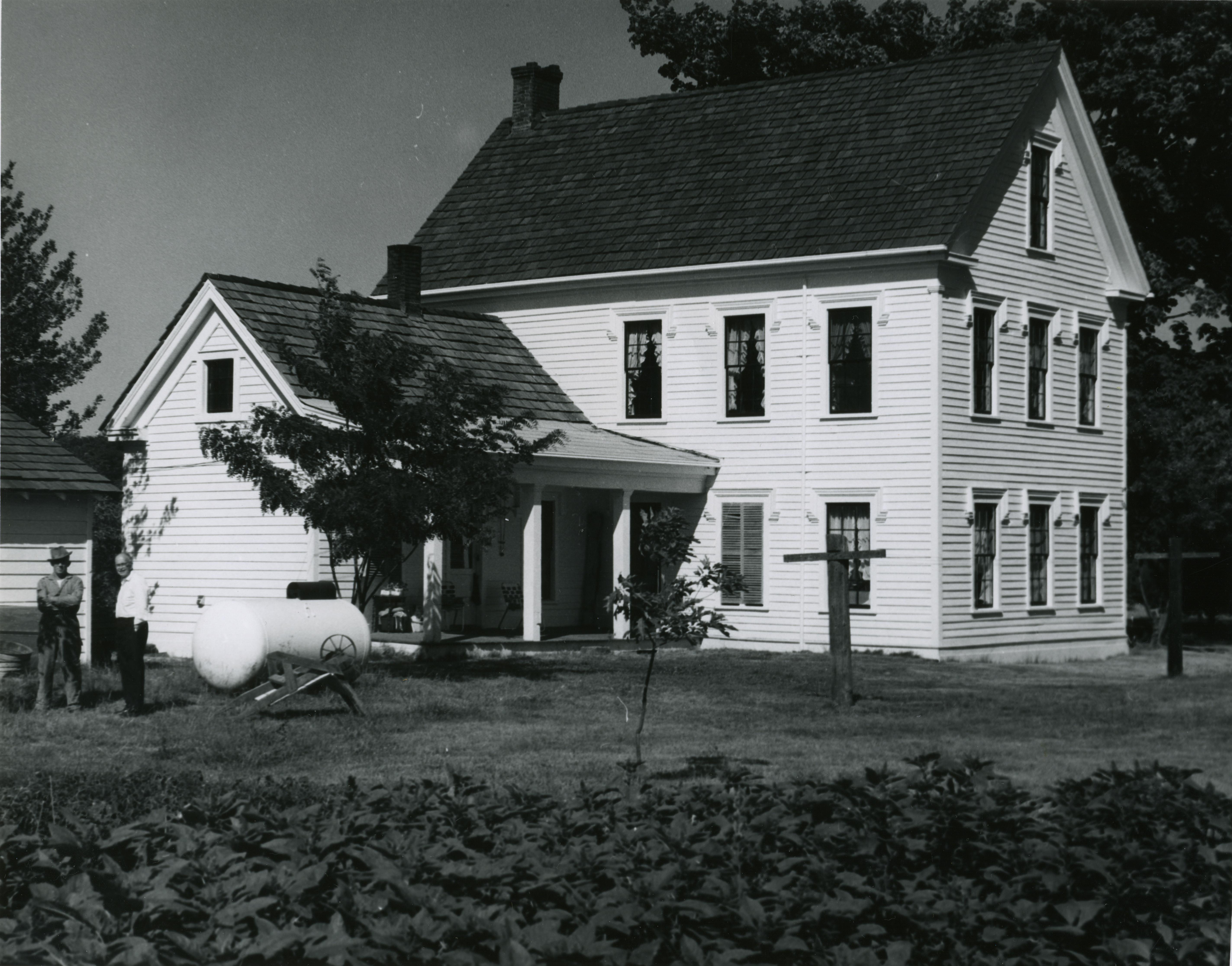
In 1859, Joseph Borst began construction of a large home for his wife that took 2 years to complete. The mansion and replica of the blockhouse still stands today at the Fort Borst Park in Centralia. The mansion, completed in 1860, was the finest home between Olympia and Vancouver at the time. Borst also built the blockhouse that would end up being only used to store grain. Later, Borst would raise cattle and become a partner of the Borst, Foss and Booth Beef Company that would drive cattle from their pastures in the Chehalis valley to Olympia.
They would also buy herds of cows in eastern Washington and drive them over Yakima pass to his brother's (Jeremiah Borst) pasture land at Rangers prairie in North Bend. The cows were left at Ranger's prairie to fatten up on the rich pasture grass before driving them over the Na-qui-a-ka trail that ran between North Bend and Renton. From there it was up the Duwamish valley to the slaughter house that was located near Spokane Street and Diagonal Way in Seattle.
After the Military Road was completed in 1861, traffic increased through Skookum Chuck as stage coaches and settlers were now coming up from Monticello as well as from the Cowlitz Landing. The Military Road at first crossed the Chehalis river about a quarter mile north of the Mellen Street bridge. After Cochran's charter expired in 1860 Ferdinand Chable became the new ferryman after receiving some financial backing from his neighbor to the north Joseph Borst. Ferdinand Chable had owned the land on the opposite side of the Chehalis east of Cochran and south of Borst. This is when the ferry was moved to cross the river between Chable's and Borst's property. In 1862, Chable sold his ferry charter to William F. Donk, who was the postmaster of Skookum Chuck between 1861 and 1863.
On January 4, 1862, the Legislature issued a ferry license to William F. Donk and Henry Ties for the operation of a ferry where the Military Road now crossed the Chehalis river near the residence of Joseph Borst. The license was good for ten years provided they keep the ferry in good condition and properly manned. The ferry was known as the Borst ferry, Donk's ferry, and the Blockhouse ferry.
A few years later the ferry was sold to Daniel Scammon, and afterwards to James C. Ready. The ferry could carry a four-horse team and wagon, or a pair of two-horse teams and wagons. It was said that ferry passengers had to work for their passage when the ferry was on the wrong side of the river. This meant that someone had to row across in one of the boats which were generally lying around, and bring the ferry back over. The craft was operated by means of a winch with blocks and cable, so arranged that the nose of the ferry, when turned upstream, caused the current to force it across the river. On the south side, the cable was fastened to a tall fir tree, and on the north, to a well anchored log piling.
Ada Smith who once lived at the old Scammon place on the south side of the river told a story about the old ferry; "One winter in the early 1880's, the flood waters were so high that the ferry cable dragged in the current. Soon a huge tree floated down and caught the cable. The tension became so great that it snapped on the north side of the river. The blocks and rigging pulled loose, and the craft was carried down the river. It eventually was caught in some bushes along the bank. When the water receded, the little old ferry was tilted against the steep bank. It soon broke in two from its own weight and there it rotted after twenty years of service. The ferry was never rebuilt
Now that stages were running on the roads, the companies needed to have relay stations along the route. The Davis Stageline had a station at Centerville (Centralia) that was run by James Tullis and was known as the "Tullis' Station." In the fall of 1867, a traveler wrote about their journey to Olympia; "We reached Tullis' Station, on the Skookum Chuck, about 2 o'clock in the afternoon, having been for some six hours exposed to a constant dripping rain. There we had dinner, and for the balance of the trip, twenty seven miles, we had a covered coach, and with relays of horses made good time reaching Olympia about 7pm."
The Military Road between the Monticello and Skookum Chuck never had any maintenance work done to it except for the poor souls who had to clear the path so they could continue moving forward, and by 1867 the road had become almost impassible. On January 22, 1867, the legislature approved $25,000 to repair the Military Road between Monticello and the Skookum Chuck.
Skookum Chuck at its peak, had a post office, Public house and later a stagecoach stop, plus a store or two in the area. The community was more or less a cluster of settlers until the railroad came through in 1873 and the town of Centralia began. The farmers primarily raised livestock and vegetables for their own subsistence and for bartering with their neighbors. Once a year they would take trips to Tumwater or Olympia to sell the surplus they grew. Until the road was opened for wagons, they were limited in their involvement in the broader economy at the Sound and at Vancouver.
The Cowlitz Trail and the Military Road, continued to be used as the only way for people to reach the Puget Sound by land until the late 1860's, when the Snoqualmie Pass Wagon Road was completed. When the railroad was completed from Kalama to Tacoma in 1873, it further diminished traffic on the roads through the Cowlitz Corridor. The locals were now the main source of traffic using these old wagon roads.
On January 8, 1875, George Washington and his wife Mary Jane filed a plat for a town that he called Centerville. There happened to be another town in Snohomish county that was called Centerville. This Centerville was established in 1866 at the mouth of the Stillaguamish river. Even though these towns were miles apart, considerable annoyance was caused by having two towns with the same name. In 1877 the Snohomish county town of Centerville was changed to Stanwood.
On July 30, 1877, the Skookum Chuck post office was moved to Centerville by James Tullis.
In 1882 another town called Centerville was established in Klickitat county near Goldendale. During the Legislative proceedings of November 1883, H. B. 107 was introduced and approved changing the name of Centerville to Centralia.
On April 1, 1884, the name of the Skookum Chuck post office was changed to Centralia. This was because the citizens of Centralia had grown tired of the multiplicity of names to describe the area. So that spring they came together and filed a petition to the Postal Department asking for the name of the post office to be changed to Centralia which was granted. Shortly after, the railroad and express companies made the change of their stations to Centralia finally ridding the town of a great annoyance by having several names for same place.
The name Skookum Chuck has evolved over the years to Skookumchuck which can still be found in Thurston and Lewis counties.
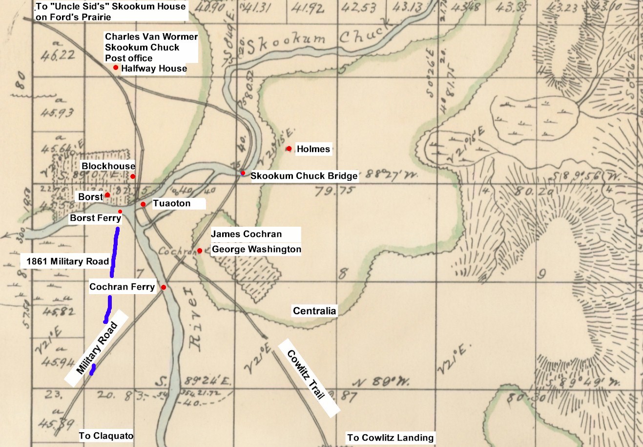
1856 map of Centralia 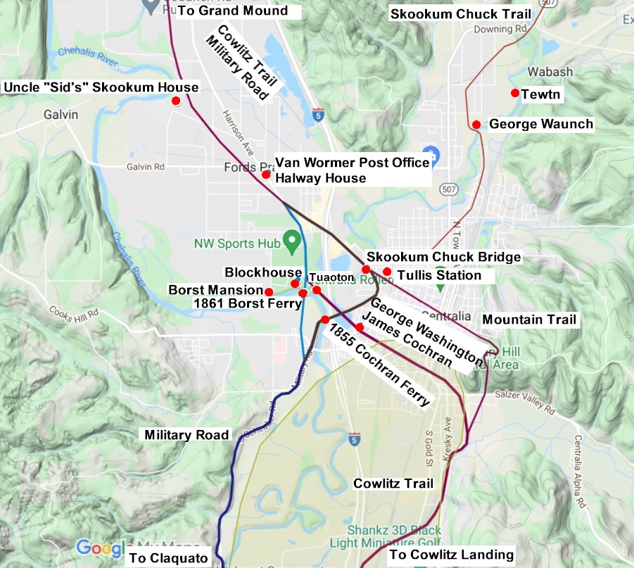
2021 map of Centralia 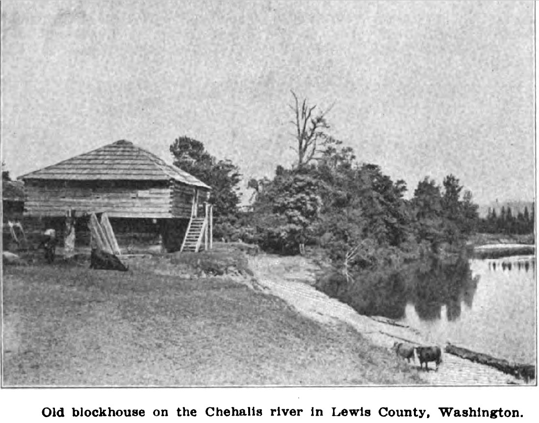
The Borst Blockhouse in 1909. This photo looking northeast was taken from the ferry landing. 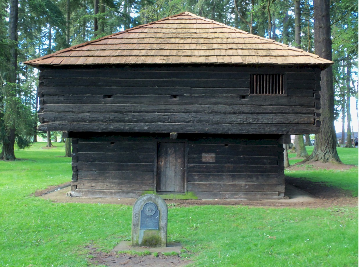
Borst Blockhouse 2011 |