![]()
The Historic Pacific Highway
in Washington
Crossing the Plains
![]()
The Historic Pacific Highway
in Washington
Crossing the Plains
The Steilacoom Plains
By Curt Cunningham
The Pacific Highway and Interstate 5 between the Nisqually river and the City of Dupont travel through an ancient drainage channel that was carved out during the Ice Age. This is when the Steilacoom plains located between the Puyallup river in the east and Puget Sound on the west were covered with the draining water from the melting Puget Sound and Mount Rainier glaciers. The water also drained through low spots now occupied by Sequalitchew creek and Chambers' creek. The water came in though low spots near Orting and South Hill, and later through South Tacoma.
When the ice retreated it left the plains covered in gravelly rocky soil while creating many beautiful lakes, that after time became full of trout. In the 1870's the prairie lakes in southwest Pierce county became a favorite destination for anglers from all around Puget Sound.
On April 4, 1878 a correspondent for the Seattle Daily Intelligencer wrote a story about this area; "One of our merchants who has just returned from a semi pleasure excursion to Steilacoom and vicinity give a glowing description description of the verdant prairies in that locality, which he says are covered with a perfect carpet of flowers. In the neighborhood of Lake View the sward is as white as the driven snow, with wild strawberry blossoms. He has visited the place frequently during the Spring months heretofore; but has never seen the blossoms in such profusion as now."
"While there he tried his hand at trout fishing on Chambers' stream, and brought back with him to Seattle a fine string of large brook trout. Trout fishing is all the rage in that section at present. While our informant was on his way up to the locality in question, he met a number of gentlemen from Tacoma, returning home literally loaded with fish. Frank Clark, who is considered something of an adept at angling, caught a string of ninety there a few days ago in a short time."
"He also related to us a rather novel and original method of catching trout in that vicinity. The waters of Lake View literally swarm with trout, and have their outlet in a stream which runs along through the prairie about a mile, and then sinks out of sight. The trout run out of the lake into the stream in great numbers following it up until they reach the place where it forms a junction with the subterranean passage, beyond which they advance no further."
"Mr. Elder, whose house is situated just below this sink, and but three and a half miles from Steilacoom, concluded to try the experiment of cutting a ditch from the point in question to his yard He put the ditch through, and at the outlet in the door yard, constructed a sort of cage trough. The trout come down the ditch and are caught in the trough in large numbers. By this means he catches all the trout he can dispose of, and many of them measure as much as eighteen inches long. No is the time to get up a picnic excursion to Steilacoom."
Byrd's Mill Road
1852
The Fort Walla Walla Military Road
1853
The Northern Pacific
The Olympia-Tacoma Road
1910
The Lakeview-McKenna Highway
The Pacific Highway
The Northern Pacific
In 1873 the Northern Pacific began building across the plains toward Tacoma. The Prairie Line as it is called today bypassed the largest towns on the Sound at the time. The tracks were 13 miles away from Olympia and 5 miles east of Steilacoom.
Lakeview
John Flett 1868 Lakeview
Lakeview was located on the Steilacoom plains about 7 miles southwest of Tacoma and 5 miles west of Steilacoom at the junction of the Northern Pacific's Prairie Line and the Olympia Line.
The City of Lakewood encompasses 17.18 square miles
The City of Lakewood had a population of 62,595 as of July 1, 2021.
An 1889 Pierce county map shows the town of Steilacoom, and the settlements of Lake View, Oakdale (Ponders), Fern Hill and Hillhurst are the only places on the Steilacoom plains.
A Pierce county map from 1897 shows the town of Steilacoom and the settlements of; Lake View, Lake City, Hillhurst, Lake Park (Spanaway), Brookdale, Parkland, Midland, Larchmount, and Fern Hill.
In 1940, Lakeview had a population of 100 and at the time was a growing community of well maintained modern homes scattered over a flat grassy parkland covered with scrub, oak and pine. In the 1840's, the Puget Sound Agricultural Company once had sheep and cows roaming the area.
The Lakeview Community Center was the first of its kind in the state. The building was an adaptation of Georgian architecture in red brick. Under one roof, all sorts of community services were provided; apartments, public and private dining rooms, shops, doctors and dentists offices, a Christian Science reading room, recreation hall, and a theatre, all decorated in a colorful modern manner. The center serves the surrounding residential area, known as the Lakes District.
The Pacific Highway in 1913, followed the railroad tracks in a NE direction from the Nisqually Bottom to Lakeview. The old road then turned to the north on what is today Lakeview Avenue SW and continued north to Steilacoom Blvd. The highway crossed over the old 1853 Byrd's Mill Road that ran between Steilacoom and Puyallup that became a part of the Territorial Road to Seattle at 100th Street SW.
The highway then turned right onto Steilacoom Blvd and continued east to what will become South Tacoma Way. In 1936, when South Tacoma Way was completed, the highway bypassed Lakeview as it continues to do today.

E 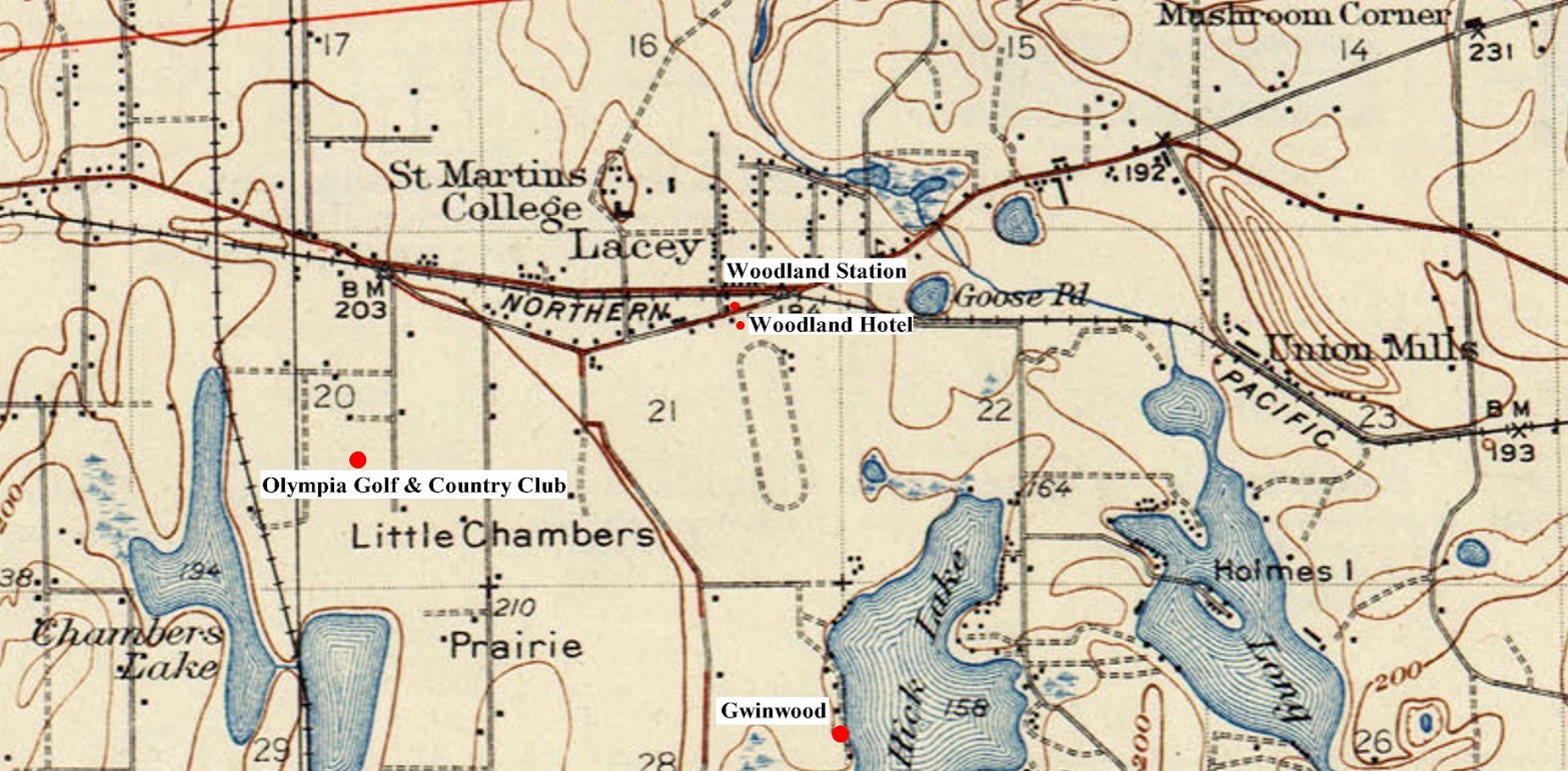
1
1 
2 |
2 
2 
V 
L |